Istanbul Ataturk International Airport (IST)
Driving Directions / Travel by Car
(Istanbul, Turkey)
Located around a 20-minute drive from the centre of Istanbul, Turkey's biggest city and the capital of the province, Istanbul Ataturk International Airport (IST) is close to the Sea of Marmara.
Ataturk Airport is situated very near to the D100, O2 and O3 motorways, allowing for fast access to Istanbul and beyond.
Also close to Istanbul Airport you will find Sümer and Zuhuratbaba to the east, Tevfik Fikret and Yenibosna Merkez to the north, and Cennet to the west. Bordering the eastern side of the grounds, the Havaalani Yolu road provides access to the two terminals and car parks.
Directions to Istanbul Ataturk International Airport (IST) from the north:
- From the O3 motorway to the north of Istanbul Airport, head in a southerly direction towards the D100
- Head west on the D100 for a short while and then take the exit south for the airport
Directions to Istanbul Ataturk International Airport (IST) from the east:
- From Istanbul and the east, head west on the D100 motorway for Edirne
- Take the airport exit south for the terminals, about 24 km / 15 miles from Istanbul
Directions to Istanbul Ataturk International Airport (IST) from the west:
- From the west and Edirne direction, take the O3 motorway and D100 east
- Turn right at the airport exit on a heading south for Yesilkoy and the terminals
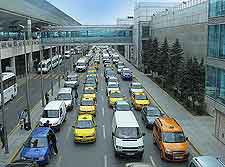
Roads into Istanbul become congested during the day, as can the D100. We recommend that you allow extra time when travelling to and from Istanbul Ataturk International Airport during morning and afternoon rush hours, and also on holidays.
