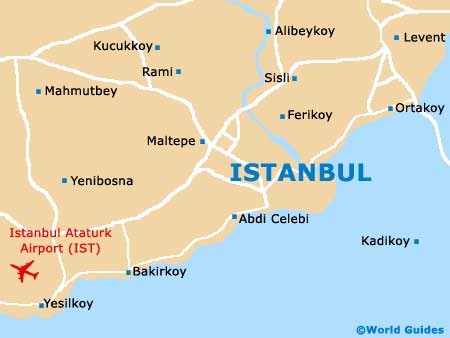
Istanbul Ataturk International Airport (IST)
Orientation and Maps
(Istanbul, Turkey)
Turkey's most densely populated city, Istanbul is home to in excess of ten million inhabitants and a thriving economic centre. With a modern skyline dominated by high-rise skyscrapers and major bridges, the city of Istanbul is also home to a number of historic mosques, palaces and the 19th-century St. Esprit Cathedral, which is located in the Beyoglu district.
Istanbul's number one airport, the busy complex of Ataturk International Airport (IST) is located in the Yesilköy area, on the south-western outskirts of the city. Also nearby, the smaller Sabiha Gökçen International Airport (SAW) lies to the east and is particularly close to the town of Heas. Both airports currently serve almost 50 million passengers each year and continue to expand to meet the heavy demand.
Istanbul Ataturk International Airport (IST) Maps: Important City Districts
Istanbul is home to three main regions, each of which contain a number of important districts. The Historic Peninsula area contains both the Faith and Eminönü districts, next to the Golden Horn estuary. This district divides the old city centre and the more youthful, modern northern areas.
To the north of Istanbul's Gold Horn, the Besiktas and Beyoglu neighbourhoods are especially historic and are close to a number of former villages. Nearby, the Kadiköy and Üsküdar were once cities in their own right and contain a number of important business districts and much of the city's overall population.
Around the city, many prominent landmarks punctuate the landscape, such as the striking Bosphorus Bridge, a long suspension bridge opened in 1973 that spans the Bosphorus strait. Those looking for the best selection of shops should consider a visit to the Etiler, Levent and Maslak districts.
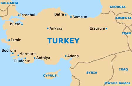
Turkey Map
Istanbul Map